Trusted Offline Navigation for Remote and Outdoor Use

Offline Maps App That Earned National Geographic’s Trust

About The Project

Industry:
Travel and Tourism
Solution:
Custom Mobile App

Services:

Offline Map Integration

GPS and Geolocation Services

Performance Optimization

App Store Optimization (ASO)

Post-Launch Support

Technologies:

Firebase

SQLite

swift

Innovative Offline Maps App

Project Overview

The client needed a navigation app that didn’t rely on the internet, one that stayed accurate even in remote areas. The goal was to build something that users could count on for offline maps, no matter where they were.

What We Did

  • Built a cross-platform offline maps app using Mapbox, AWS, and Firebase
  • Designed a clean, responsive UI for iOS & Android, balancing ease and control
  • Engineered lightweight auto-updates to keep offline maps fresh without heavy data use
  • Added activity-focused layers for hikers, bikers, and photographers
  • Integrated real-time GPS tracking that works fully offline in remote zones
  • Implemented transparent data provider info to boost user trust
  • Optimized performance for low-signal environments with caching and smart rendering

Offline GPS and Navigation for Remote Explorers

The app allows users to download maps ahead of time and navigate them without Wi-Fi or mobile data, perfect for outdoor activities like hiking, camping, and field research. It uses built-in GPS to track location in real-time, even with no signal, and supports accurate offline maps using Mapbox and OpenStreetMap across all kinds of terrain, woods, mountains, and rural areas.

🧠 Did You Know?
The Global GPS Market is expected to grow from $119.47B (2024) to $402.43B (2032) at a 16.4% CAGR.

Intuitive Mobile UI/UX for Effortless Map Interaction

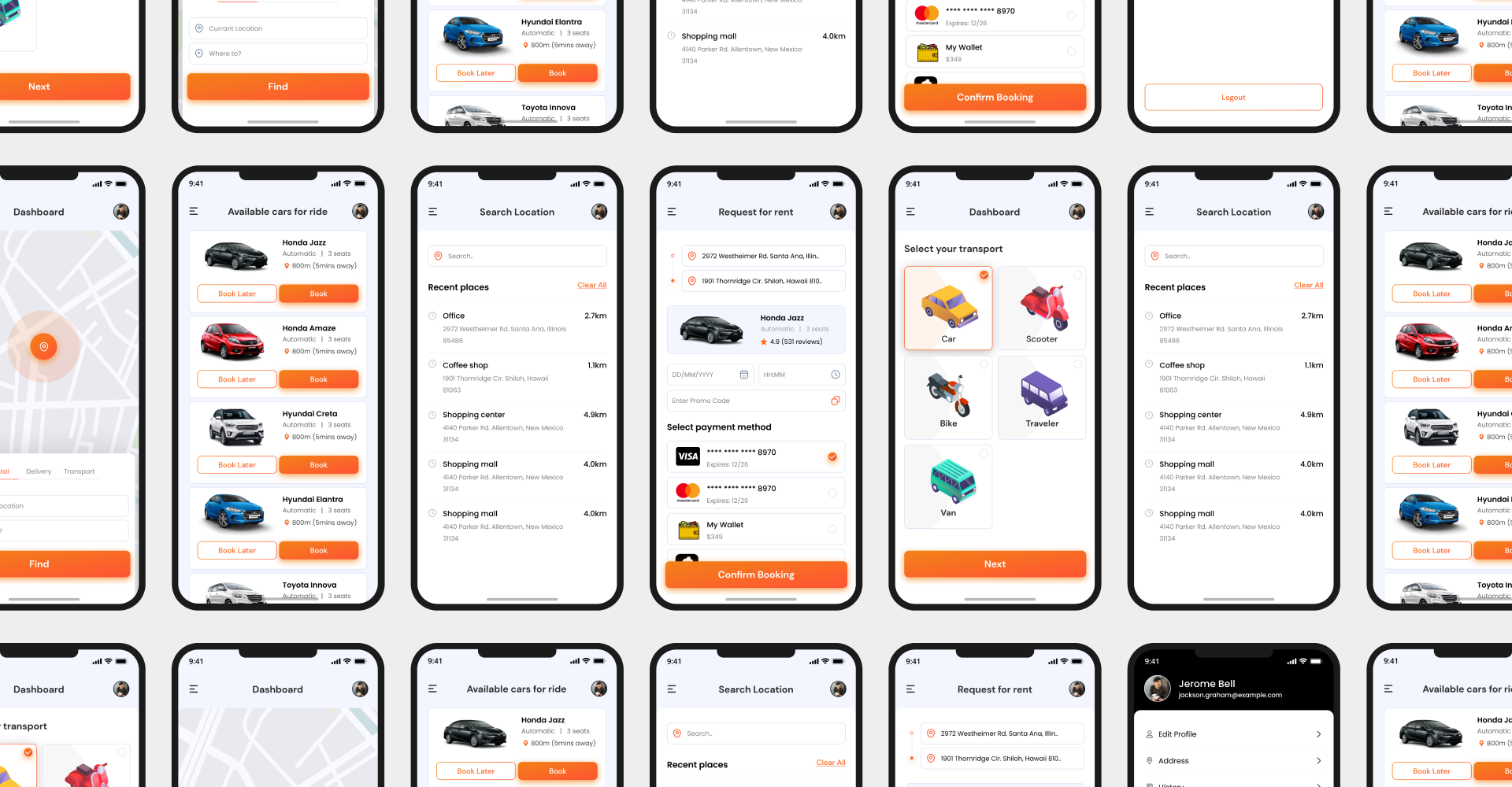
eSparkBiz designed a clean, easy-to-use interface for explorers of all kinds. The app includes interactive maps, simple location pins, and easy-to-follow routes to help users stay on track. It works on both iOS and Android with a responsive layout, clear route visuals, and smooth zooming and panning so users can move through the map without hassle.

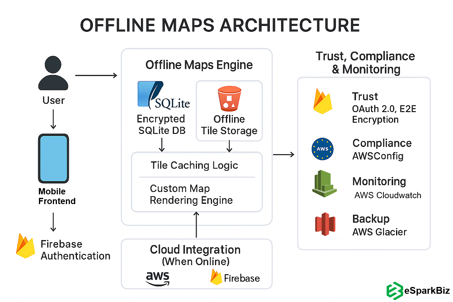
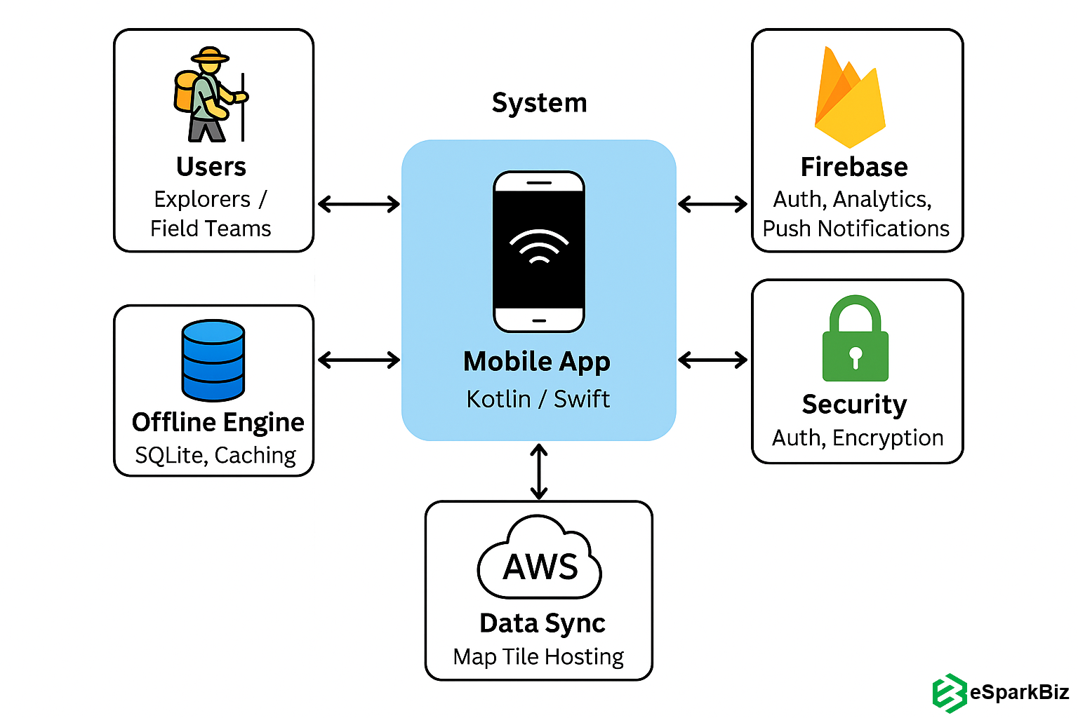
Designed for field users, it integrates Firebase services to support smooth navigation, feedback, and UI responsiveness across devices:

Offline Maps Architecture

Offline Maps App Built for iOS/Android, Trusted by Nat Geo

eSparkBiz built a cross-platform app using Mapbox and OpenStreetMap to deliver reliable, real-time map access. It provided smooth GPS tracking and offline navigation, earning trust from National Geographic for field missions with no connectivity.

Optimized App Performance for Low-Signal Environments

Because this app is used where there’s little to no internet, its performance needed to be rock-solid. eSparkBiz made sure it runs reliably in offline or weak-signal conditions. Our developers added smart caching and efficient map rendering, which kept things fast and smooth. Users never faced delays even when they were deep in the wild.

📣 📈 Industry Insight

The GPS Tracking Device Market was valued at USD 3.17 billion in 2023 and is expected to reach USD 10.03 billion by 2032, growing at a CAGR of 13.69% over the forecast period 2024-2032.

The Problem

The client faced a number of challenges while building an offline maps app for real-world use. From maps not working without signal to a poor user experience, current apps can’t meet the needs of remote travel.

Navigation That Fails Without Internet

Most mobile map apps stop working when there’s no internet. In remote areas, that’s a problem because users can’t get directions when they need them most. The client needed full offline navigation for areas with no signal at all.

Lack of Reliable Offline Map Data

Many apps couldn’t show accurate offline maps. The client wanted detailed map data with trails, topography, and landmarks, must-haves for navigating in areas without live updates.

Poor Balance Between Simplicity and Control

  • The available apps didn’t serve both beginners and pros well
  • New users found most interfaces messy and hard to follow
  • Experienced users wanted more advanced tools
  • The challenge was to design one clean, usable interface for both

Unstable Performance in Low-Signal Zones

Without a good signal, some apps became slow or crashed. This created delays or failures right when users needed the app the most, making it unreliable in key moments.

Risks of Navigation Failure in Critical Conditions

Offline failure wasn’t just annoying, it could get dangerous in isolated place scenarios like:

  • Field teams couldn’t afford to lose app access mid-mission
  • Missed or wrong route info caused delays or safety risks
  • Poor app performance could lead to mission dropouts or worse

Inconsistent experience across different devices or platforms

Users often face frustration when map features or performance differ across devices. Delivering identical offline maps, UI, and navigation everywhere builds trust, supports multi-device workflows, and ensures a consistently reliable user experience.

Outdated Offline Maps

Relying on static offline maps risks using outdated routes and missing new points of interest. Users often find map data stale just when accuracy matters most, leading to frustration and reduced trust in navigation reliability.

Limited Activity Customization

Offline maps often feel generic, missing tools for unique outdoor adventures.

  • Users can’t highlight hiking-only routes or bike trails
  • Lack of specialized overlays for photographers or climbers
  • One-size-fits-all view frustrates activity-focused users

Unclear Map Data Sources

Unverified map data makes users question accuracy and trust.

  • Users don’t know where map data comes from
  • Doubts about coverage gaps or outdated regions
  • Lower confidence in planning critical routes

The Solution

eSparkBiz built a strong mobile app that solved every challenge from offline access to real-world reliability, making sure users had smooth and trusted navigation in remote and off-grid areas.

Offline Map Access Anytime, Anywhere

eSparkBiz used Mapbox and OpenStreetMap so users could download detailed maps before trips. These maps worked without a signal and showed terrain, trails, and landmarks vital for off-grid travel.

User-Focused Design for Effortless Navigation

The app’s simple layout worked for both casual and advanced users. Easy gestures, clear icons, and smart routes made navigation easy. With pinch-to-zoom, route lines, and pin drops, users could focus on their trip, not their phone.

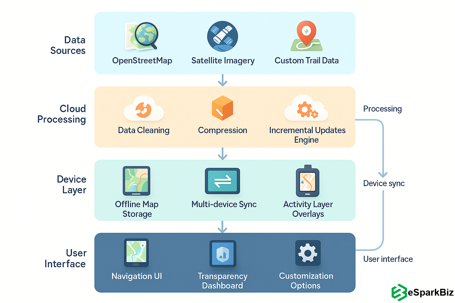
The workflow below illustrates how offline maps, GPS, and user tools connect across layers for real-world navigation:
Offline Maps App Workflow

Seamless GPS Navigation Without Connectivity

The app was made to work without the internet and still give full GPS support, perfect for remote exploring.

  • Gave turn-by-turn directions without a data connection
  • Kept real-time location visible even offline
  • Showed routes clearly on the downloaded map areas

High-Performance Experience in Remote Areas

eSparkBiz made sure the app stayed fast, even with a low signal or limited device power. Every part of the app was built to handle remote use. It used smart storage and caching to load big maps fast. Battery-friendly features helped it last longer outdoors in forests, hills, or remote trails.

Consistent Navigation Across Platforms

The app was built for both iOS and Android and worked the same on each. This way, all users got the same experience, no matter their device. From screen behaviour to how the maps moved, everything stayed smooth across systems, keeping explorers focused on the trail, not the tech.

Built for Reliability in Critical Environments

The app was tested to make sure it wouldn’t fail in tough conditions where internet and power are limited.

  • Built to resist crashes even in low-resource settings
  • Operated fully offline without needing live data
  • Remained stable throughout extended field missions

Tailored Layers for Outdoor Needs

Custom layers turn maps into trip-ready tools.

  • Highlight trails, elevation data, or bike paths instantly
  • Add photography points, shelters, or campsites
  • Personalize views for specific outdoor activities

Auto-Updates Without Extra Data Use

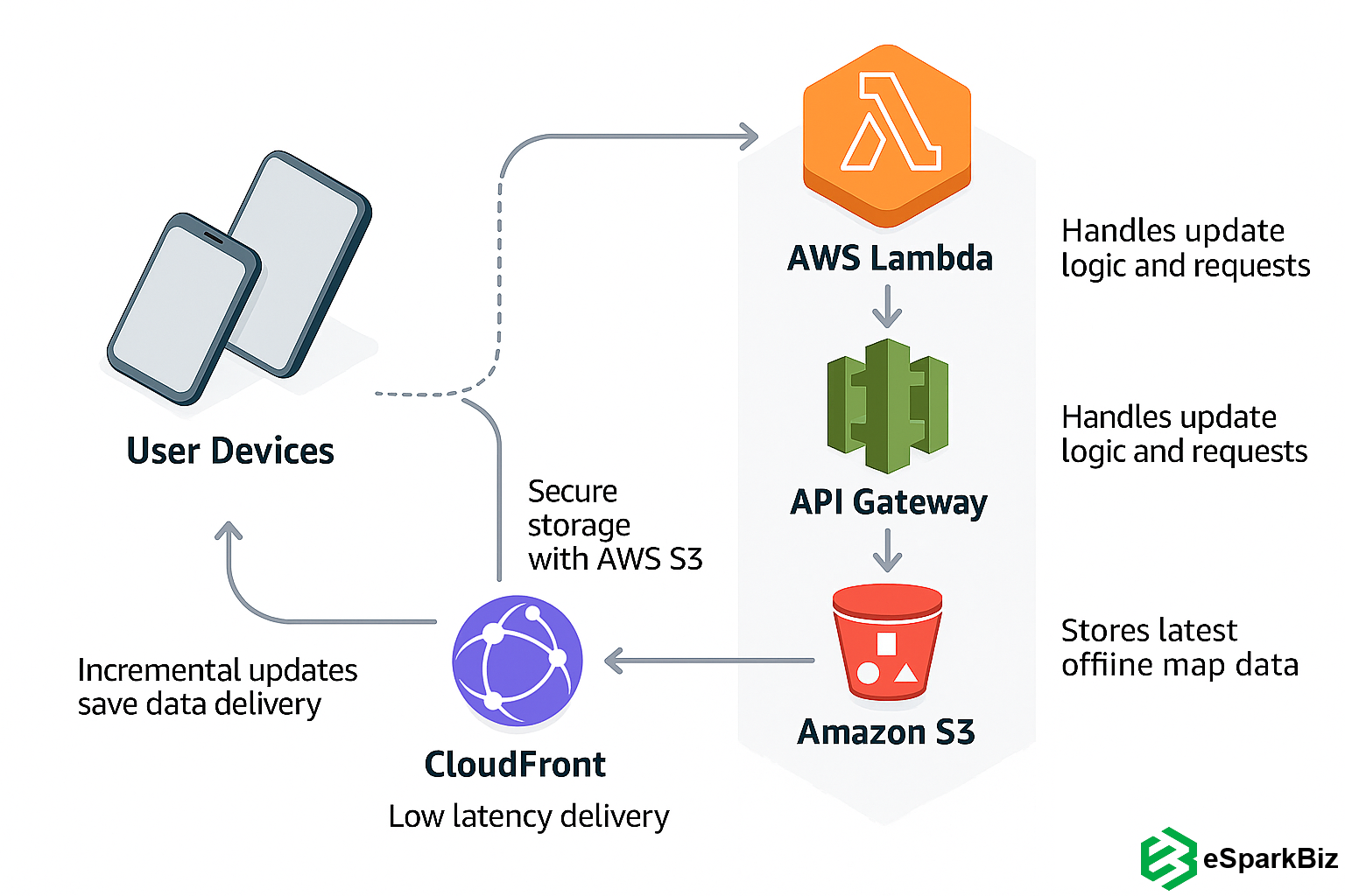
Lightweight background updates refresh offline maps automatically, keeping data current without draining mobile data or battery. This ensures travelers always have the latest routes, landmarks, and coverage, even in areas without strong connectivity.

The AWS-powered architecture below enables secure, low-latency delivery of incremental offline map updates to mobile devices.:
AWS Architecture for Offline Maps App

Transparent Coverage & Providers

Clear source info builds trust and reliability.

  • Show map providers and update dates visibly
  • Display real-time coverage strength by region
  • Help users plan confidently with verified data

The Result

Users could download maps and access GPS anywhere, no matter the conditions. The app was built for real-world use and delivered exactly when it mattered most.

  • Empowered Exploration: Users could download high-quality offline maps and explore confidently without needing a connection.
  • Accurate, Real-Time GPS: The GPS tracking stayed reliable in off-grid areas, helping people stay on route without relying on the internet. 
  • Enhanced Map Freshness: Auto-updating offline maps meant travelers had the latest routes and points of interest, even without signal.
  • Activity-Ready Navigation: Customizable layers supported hikers, bikers, and field photographers with terrain-specific details.
  • Greater User Trust: Clear map data sources and coverage transparency built confidence for trip planning in remote areas.

Users gain confidence with verified data origins, updated visibility, and consistent coverage across all terrains.

Offline Map App

  • Recognized Innovation: National Geographic praised the app for its strong offline navigation features, recognizing its value in field exploration.
  • User Satisfaction Climbed: With its simple UI/UX design and solid performance, users found navigating much easier and safer on outdoor trips.
  • Reliable in Any Environment: The app held up well even in low-connectivity areas, becoming a go-to tool for remote navigation.
  • Confidence Under Pressure: Even in long missions with no internet, the app stayed dependable, helping users avoid data loss, trail confusion, or delays in critical conditions.

Need Customized Navigation App Solution?

GAMP4-Compliant Software to Automate Cancer & TPN Drugs Manufacturing
purple-eb-hexagon

GAMP4-Compliant Software to Automate Cancer & TPN Drugs Manufacturing

Reduced Manual Work by 65% Using Automated Car Wash Web & Mobile Solutions
purple-eb-hexagon

Reduced Manual Work by 65% Using Automated Car Wash Web & Mobile Solutions

Request a Quote Schedule a Meeting